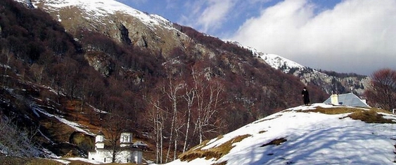
Geographic Location
The Buila-Vânturariţa Massif is located in the central-northern part of Valcea County is one of the Căpăţânii Mountains massifs. This massif differs by the main mountain chain by its layout, structure and relief. The main chain of Căpăţânii Mountains, made mostly of schists, lies from east to west, with secondary peaks in its north and its south, except two limestone massifs, whose main peaks lie from south-west to north-east. These being the Tarnovu Massif (north-west) and Buila-Vânturariţa Massif (south-east).
The Buila-Vânturariţa Massif lies from the western corner of Bistriţa Gorges to the eastern corner of Olăneşti Gorges (also called Folea Gorges). The connection with the Căpăţânii Mountains is made through the Netedu Plateau (located between the Bistriţa and Costeşti rivers), the Lespezi Plateau (between the Costeşti and Cheia rivers) and the Hădărău Plateau (between Cheia and Olăneşti rivers).
Buila-Vânturariţa Peak is configured as a line in length, 14 km long and 0.5 to 2.5 km wide, (due to the expansion of Jurassic limestones).
The maximum elevation of the park is at the summit of Vânturariţa Mare peak (1885 m), and the minimum is at the exit of the Bistriţa River from its gorges (550 m). The main peaks of the massif, starting form south-west to north-east, are: Arnota (1183.7 m), Cacova (1525.1 m), Piatra (1643 m), Albu (1658.9 m), Buila (1848.6 m), Ştevioara (1847 m), Vânturariţa Mare (1885.2 m), Vioreanu (1866 m), Vânturariţa Mică (1655 m), Stogu (981 m).


)