Hiking duration:
- on summer: 4 ½ - 5 ½ h
- on winter: not recommended from Plaiul Zănoaga to Curmătura Rodeanu
Refuges: the Bistriţa Monastery, The Forestry Station Between rivers, the refuge on Bistriţa Valley, the ones at Cuca Mică, Zănoaga and Rodeanu Sheepfolds
Water sources: the Bistriţa Monastery, Chirachide’s Fountain (on the Bistriţa Gorge), Between rivers, the refuges at Cuca Mică, Zănoaga and Rodeanu Sheepfolds
Description:
This is thee hiking trail that crosses the Buila-Vânturariţa National Park from north to south, thus connecting the southern locations to the main ridge of Căpăţânii Mountains.
The trail starts from Bistriţa village, at the gates of Bistriţa Monastery, to be precise, where there is an information board and an arrow pointer. The trail overlaps (in its initial part) with an ecotourism trail, set up in the National Park.
It’s a long, but not very difficult trail, mainly cut out on forest roads.
It heads north on the forest road on Bistriţa Valley. 100 m further down that road, it reaches a crossroad (the road that cuts Bistriţa River over to the right, goes up to the limestone mine and to the Arnota Monastery, and is 4 km long). Another 100 m further, our trail gets right next to the monastery, where there’s another crossroad, with an arrow-pointer, marking the meeting with trail no. 2 (blue line), that goes to the main ridge of Căpăţânii Mountains, passing by the Arnota Monastery, the Arnota and Prislop Peak. Following the forest road, it passes the barrier and reaches the access point into the National Park on the Bistriţa Valley, which is the same as the point where the Bistriţa river exits its gorge, a point marked by another information board and by the sign for the national park’s boundaries (a red square with a white frame). There’s also an arrow pointer for the Bats’ Cave (the Cave of Saint Gregory the Decapolite).
Once you enter the gorge, 200 m further, you will pass over a bridge, where the gorge gets narrower. There is another wooden panel here, with information on the gorge, and a garbage box. From hereon starts the narrowest part of the gorge, 1 km long. The Bears’ Cave is located in this area, the access being pointed out by an information board and an arrow-pointer. Before reaching the area where the valley widens, you will pass a small restplace whith a fountain (Chirachide’s Fountain). The valley begins to widen as soon as you pass the limestones area. There is a small glade on the right and then a small trout lake, and then, an even larger area, with glades on both sides of the road. On the right side, before passing over a bridge over Bistriţa, there is a campground (information panel, wooden table, benches, fireplace, garbage box). 200 m further from the bridge and 4,3 km away from Bistriţa, you will reach a crossroad and a confluence of streams (Gurgui on the left and Cuca on the right), a place called Between Rivers. There are a few buildings here (forest station, refuge property of the National Park, a hydroelectrically power plant etc.) and a spring.
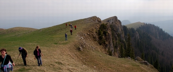
From the crossroad, the trail goes right, on the way to Cuca Valley. Passing by the wooden building of a fruit-collecting center (on your left); 300 m further you will get to the blue cross marked trail, no.4. At 4 km from „Between Rivers”, the trail passes the ex refuge I.F.Bistriţa, and about 1 km further, you will exit the main road, going up the forest road on the left, on the Cuca Mică Valley. About 500 m further, the trail crosses the river Cuca Mică, then goes up on the left to its spring. After half an hour going up on this secondary road, there is a spring and a refuge. From here, the trail goes left on a tractor road and then starts upwards on a winding road on the western slope (a deforested area) of the Cuca Mică Stream. 15-20 minutes later, there comes a small pass, at the source of the spring, where there is another shelter. From here, the trail enters the forest and, after 5 more minutes, it reaches the ridge, where there is a hunting hide-out, under Cuca Peak. The trail crosses over to the eastern slope through a deforested area and then it goes down to a pass called „By the springs”, where there are deforestation works in progress. Then it goes up the forest ridge, passing close by a forestry station, right as you go into the woods. Before reaching the Zănoaga Peak (1662 m), you will go up the rocky area called „the Court Stairs” and get to the alpine meadows area. From this point on, the marking sign is painted on rocks, mostly at ground level, nevertheless it is very easy to follow the trail, as it goes on the range line. Going up the Plaiul Zănoaga range, you’ll reach a small peak, and from there you go down the Zănoaga sheepfolds (spring, two sheepfolds and a shelter). The trail proceeds up on the tractor road over to the main ridge (forested in this area), passing by another sheepfold and turning left when getting to the forest limit. It continues down the forest line for a while, then gets into the woods and keeps going on level curves up to Curmătura Rodeanu (1628 m), where there is a sheepfold and where it meets the tractor road that goes on the main ridge of Căpăţânii Mountains.


)