Hiking duration:
- on summer: 4 - 5 h
- on winter: forbidden from the Oale Sheepfold to Curmătura Oale
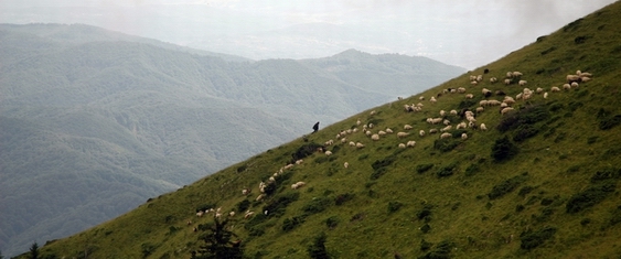
Refuges: the Pahomie Hermitage, the Oale Sheepfold
Water sources: Pahomie Hermitage, Oale Hermitage, The Comarnice Spring
Description:
The trail connects the north-western slope to the south-eastern one of the Buila-Vânturariţa Massif.
It is a difficult trail, due to the great difference of altitude between the start point and the end point (almost 1000 m) and to some exposed parts in the upper side, that is why it is closed on its alpine meadow track.
From the Pahomie Hermitage, the trail goes downwards on the forestry road to Cheia, pass the Beautiful Spring and, 100 m further, there is the pointer that marks the start point of the trail. Going upwards, through the young, rare woods, to the east, you’ll get to the ridge, where there is a forestry exploitation. Course changes from hereon, and you’ll get up north to the ridge. 10 minutes later, you’ll pass the forestry exploitation and enter the old beech forest. Crossing a few dry valleys on your right, a strenuous ascent follows, on a rich vegetation valley, and, at 2 hours from start time, you’ll get to the Oale sheepfold (an old building and a new one). From the sheepfold, the trail goes upwards to the north, gets into the forest and, in a small pass, there is a spring. Going right again from here, you’ll reach a moorland valley, surrounded by woods. The trail goes up the valley, on the right at first, by the edge of the forest, then straight on the course of the valley, to a detrital area, where the valley narrows down. Cross the valley, comes the spruce forest. The trail is more obvious from hereon. Going upwards to north-east, you’ll cross a few small valleys and after 40 minutes, get on the main ridge at Curmătura Oale (1450 m), where there is an arrow-pointer, showing the crossroad with trail nr. 11, marked by the red dot.
From Curmătura Oale, the trail proceeds downwards on the left, on the north-western slope, through the woods. After 30 minutes of descent, you’ll get to a spring and, after 10 more minutes of ascent, you’ll find yourself in the Comarnice Glade, where the trail ends. The arrow-pointer set here, marks the crossroad with trail nr. 5, signed by a red triangle, and with trail no. 17, signed by a blue line. The Cheia Refuge lies at a 2 hours’ walk from here.


)