Hiking duration:
- on summer: 8 – 9 h
- on winter: not recommanded between Plaiul Lespezi –Zmeuret Saddle
Refuges: Cheia Chalet, Lespezi Sheepfold
Water sources: Cheia Chalet, Comarnice Spring, Lespezi Sheepfold, Lespezi Refuge
Description:
The trail makes the connection between Buila-Vânturariţa Massif and Căpăţânii Mountains, through Plaiul Lespezi.
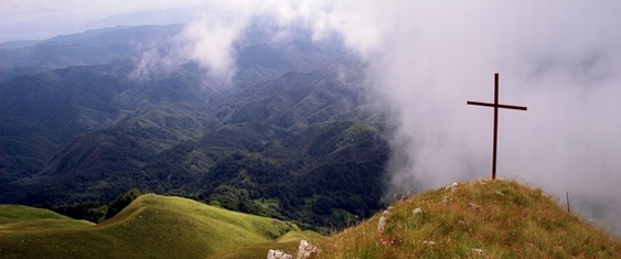
It is a difficult trail through its length and the big elevation range that has to be covered (over 1000 m).
The trail, overlapped on its first part with trail no. 5 marked with red triangle, ascends along Comarnice spring. After 10 minutes it leaves the valley line ascending on the right slope. The ascent is done, at first, on an old tractor road with abounding scrub vegetation (7 curves to the left), and then from a huge sycamore maple tree on a foot path to the west. After 1 hour of ascent, it turns left to Poiana cu Bulbuce (cca. 1320 m), and then on a small plateau with spruce trees, after which it leads to a height, from which the track changes course towards south-west. The trail follows the eastern slope of the ridge, through a spruce tree forest and, 2 hours after leaving the chalet, it reaches a glade where the ruins of a sheepfold can be seen. Here there is an arrow-pointer which marks the intersection with the trail no. 10 marked with yellow dot, which leads to the peak and descends to Schitul Pahomie. After a 5 minutes walk on this trail, wereach a spring. From the glade it ascends west through the forest and, after 5 minutes, it reaches the peak Curmătura Comarnice (1525 m) in another glade, where it leaves Trail no. 5 marked with red triangle, which leads to Pietreni Village.
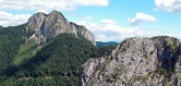
From Curmătura Comarnice, the path follows the ridge to north-west passing through Poiana Lungă (1580 m) and Groşii Bodeştilor ridge, reaching Poiana Rotundă (with a hut ruin) after 1 hour. From here on, it reaches the alpine pastures in 10 minutes and, after another 15 minutes, it ascends on the Scânteia Mountain (1685 m) from where the most spectacular view of the north-west slope of Buila-Vânturariţa ridge can be seen. From here it leads on the edge, passes along 2 little peaks and reaches a saddle at the origin of Costeşti spring (spring at 100 m). From here it ascends on sheep paths to Netedu Peak, it passes a sheepfold (on the right) and, in 30 minutes, it reaches a road where there is an arrow-pointer which marks the crossing with trail no. 2 marked with yellow triangle which ascends from Pietreni.
From here, it descends for 15 minutes to the refuge at Curmătura Lespezi (1610 m). From here, it ascends on the road to north and then left, it crosses origin of Bistriţa spring through a sinuous road and continues until it meets a crossing where the direction changes, the trail turns right towards Cheia river source (Valea Recea/Cold Valley). It almost reaches the source of the spring (on the right, you can see the foamy waterfalls and, beyond the valley, some sheepfold ruins) and then, following another sinuous road (left) which goes round Govora Peak (1957 m), it reaches the main ridge of Căpăţânii Mountains in Zmeuret Saddle situated west to Zmeuret Peak (1978 m). A short pathway, recommended especially when descending, is the direct one cutting the large sinuous road.


)