Hiking duration:
- on summer: 8-9 h
- on winter: not recommended from At the Lake Saddle – Gera Peak
Refuges: Prislopel Saddle refuge, the Old Sheepfold
Water sources: At the Lake Saddle, Hădărău Saddle, the Old Sheepfold
Description:
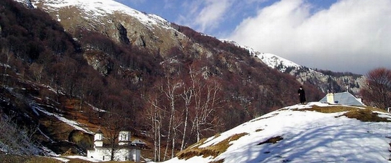
This is one of the 4 trails that connect Băile Olăneşti city to the Buila-Vânturariţa National Park.
The trail starts from the center of the Băile Olăneşti resort (430 – 520 m), on the street that goes up nearby the park to spring no. 24; 2 km further, you’ll see the Comanca camp and chalet. Before the bridge over the Olăneşti River, there is the arrow-pointer that marks the crossroad with trails no. 14, marked by the yellow line, and 16, yellow triangle, that goes upwards on the Olăneşti Valley. The trail overlaps with trail no. 15, marked by the red cross (see the description), until it gets to the At the Lake Saddle.
From the At the Lake Saddle, you start the ascent to the Cheia Chalet. You’ll leave the road where it makes a tight curve to the left, and go upwards on a tractor road, through a rare forest, first to the north, then over to north-east. 10 minutes later, you’ll get on top of a ridge, close to the tractor road (there is a forestry exploitation plot on your right), wherefrom you go up on the ridge through the woods. 15 minutes later, you’ll get into the saddle, at the bottom of the limestone slope, wherefrom you’ll change track again, over to north-east. The path slides among the limestone cliffs, going round Mount Stogu, by its bottom. You’ll pass another saddle, located in the eastern corner of Mount Stogu (the Hădărău Saddle), wherefrom you’ll go to the west. You’ll cross a valley with a spring and get up on the ridge, in the northern corner of Mount Stogu. The trail goes on to the north, on the Hădărău Ridge and on its right side and, after 15 minutes, you’ll get into a small glade where you can see the ruins of some funicular pillars. About 100 m further, there is another glade, where you’ll find the intersection (arrow-pointer) with trail no. 18 (see description), marked with a red triangle, that ascends to the Cheia Chalet and goes along with our trail, up to the main ridge of the Căpăţânii Mountains.


)