Hiking duration:
- on summer: 8-9 h
- on winter: not recomended from Netedu Plateau to Zmeuret Pass
Refuges: the shelter at the Priboi Spring, the forestry station Gura Plaiului, the Netedu sheepfold, the Lespezi Refuge
Water sources: tthe Priboi Spring, the Netedu sheepfold, the Lespezi sheepfold
Description:
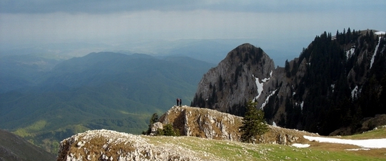
The trail starts from the village of Pietreni (same as trail nr. 5, that goes to the Cheia hut), crosses the Buila-Vânturariţa ridge on the Valley of Costeşti river and reaches the main ridge of Căpăţânii Mountains, in the Zmeuret Pass.
The trail partly overlies (at its beginning) on an ecotourism trail set up in the Buila-Vânturariţa National Park.
This is a long trail, but not particularly difficult, following, mainly, forestry roads.
The starting point is the village of Pietreni, at the crossroads with the Bărbăteşti village road, where there is also an information board and an arrow-pointer. You start to the north, and 100 m further, you reach the crossing point of several roads and trails (marked by an arrow-pointer). On the right, there is the road that goes to the Cheia refuge (trail no. 5), and our trail continues on the forestry road on the left. 200 m further, there is another crossroad with an indicator, and from there you can go left for 500 m, to the 44 Springs Hermitage (information panel). You continue going up on the main forestry road, pass by the last houses and get to a barrier, set at the entrance on this valley in the Buila-Vânturariţa National Park, marked as such by an information panel. From here, the road goes up in a winding road up to a sightseeing point, with a view for the southern villages and the Costeşti Gorge (information panel). You keep going up for another half an hour, on the road on the right side of the river, getting closer and closer to the water. As you leave the limestone ridge behind, the valley widens and the river stream quiets down. Another 15 minutes later, you reach a shelter, where there is a spring (the Priboi Spring) and an information panel. From here, the road goes north and, 300 m further, before crossing over the river on a bridge, you get to a marked crossroad. To the right starts trail no. 11, the Buila-Vânturariţa ridge trail, marked with the red dot. Once past over the river, 100 m further, there is a crossroad, and from there starts the trail no. 4 to the Bistriţa Valley. Going on the main road, you pass two nurseries and, 15 minutes later, you get to te forestry station Prislop, where you can fiind a campground. The trail goes on to the north, on the same forestry road, that follows the river stream. 30 minutes later, you reach the wooden building of a fruit collecting center; it’ s here that you can see the trail no. 6 setting off on your right, marked with the yellow triangle to the Bărbăteşti village (there’s a pointer). Another half an hour later, you reach a confluence point (another pointer), and from there, the trail leaves the main valley and goes on to the north on the Spring of Ignat Valley, an affluent on the right of Costeşti river. The road gets bad from here, and you will have to walk down the valley from here on. Keep this track for 30 minutes, to the end of the forested lot (on the left slope), where you leave the valley, going up to the left, on the tractor road of the forest exploitation plot. 20 minutes later, you reach the top, and after 5 more minutes of going north, at the connection with trail no. 2 (blue line, there’s a route pointer), that comes up on the ridge from Bistriţa village. From here, the two trails (2 and 3) go on together up to Zmeuret Pass (go to trail nr. 2 for the rest of the description).


)