Hiking duration:
- on summer: 5 – 5 ½ h
- on winter: recommended from Pătrunsa Hermitage to Costeşti Valley
Refuges: the Scărişoara refuge, the Pătrunsa Hermitage, the Curmătura Builei refuge, the Stone Cross refuge
Water sources: Scărişoara glade, Pătrunsa Hermitage, Curmătura Builei, At the Stone Cross
Description:
This trail is rated as highly difficult, due to the high altitude level differences, (almost 1000 m to climb and 800 to descend), that cross the Buila-Vânturariţa ridge from south to north, in its middle part.
The trail starts from the Bărbăteşti village, at the end of the village, to be more precise, where the range of houses ends, same as trails no. 7 and no. 8. These two go upwards on the Otăsău valley, while trail no. 6 goes up on the intervalley between Otăsău and Costeşti.
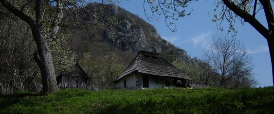
The beginning of the trail is marked with a pointer, wherefrom, following the arrow, you will cross the Otăsău on a bridge, then slope upwards on its right bank on a path, up to the back of the hill. Going up the hill, you will cross a locust trees forest and, after 15 more minutes, you reach an area of grasslands, ferns and birch trees. The path goes up the hill, on the forest line, on the limit of the woods, until it reaches a valley, on which it goes up on a grassland where there is a small glade surrounded by old beech forests. From hereon, you have to switch direction to north-east, pass by a spring, then, passing through another valley, you get back on top. The trail gets very wide from here, and you’ll have no problem to follow it as it goes slowly upwards to the green ridge. About an hour later after departure, you will get into a small pass, wherefrom you can see the forestry road on your left, going up from Pietreni to Valea Morii, where it comes across the boundary limit of the Buila-Vânturariţa National Park (marked by a white framed red square). Climbing up a small peak and then downwards again, through the woods, you will get to the road in a pass, close to a timber exploitation platform, where you come across trail no. 5 (red triangle) that comes up from Pietreni (there is an arrow-pointer). After 5 more minutes on the top, you will get to the Scărişoara glade, on a track that followed both by trail no. 5 and by the boundary of the National Park. In the Scărişoara glade, there is a campground, a refuge, a spring and an information panel.
From hereon, you cross the glade over to the east, up to the ridge, where you get a wonderful view to Mount Cozia and Mount Narăţ. From the ridge, you have to shift to the north, to get into the woods and go round the rocky area by its eastern corner. After 100 m, you reach a valley where there is a crossroad with an arrow-ponter, wherefrom you will leave behind the trail nr. 5, that goes up to the ridge and then downwards to the Cheia refuge. The trail continues through the beech forest over to the east, keeping up on the level curves until you get to the Pătrunsa Hermitage. You will pass 4 small valleys easily, and get to the 5th one, wherefrom you will go down more, into a glade (Bulzului Glade) where you can see the ruins of an old shelter. From the lower part of the glade, the trail retakes its course to the east, crosses a small ridge and reaches a crossroad with an arrow-pointer; the trail no. 7 (blue cross) goes to right from here, for the village of Bărbăteşti. You will proceed upwards, carrying the same course, and, about 100 m further, you will get on a range where there’s a white marble cross and another crossroad (always with trail nr. 7, that goes upwards from here, on the left, to Curmătura Builei). You only have one more valley to pass (proceed downwards through the glades, then through the beech forest, cross the rocky bank of the stream and then up to the wide glade), the Otăsău Valley, to arrive at the Pătrunsa Hermitage. Going past the first few houses of the monks, you get to a range wherefrom you can see the new church and the other dwellings. You will cross trail no. 8 (arrow-pointer), marked by a red cross, that comes from Bărbăteşti and goes on to the Cheia village. 50 m south from the pointer, there is an information panel, and 100 m further after going down through the glade over west, there is an information panel and a campground. You will also fiind water at the spring here.
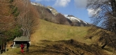
From the pointer at Pătrunsa, the trail goes up the range ahead, passing through the grasslands to the north, near the dwelling of a monk, and 15-20 minutes after leaving the glade, you will get at the bottom of a rock. The trail goes round it on the left and, about 100 m further, it gets to the Stone House, an impressive natural limestone vault, set between two cliffs. You will go round the left side of the cliff until you reach on top of the range again. Shortly after that, you will get aut of the beech forest into the alpine meadows. The track changes course to the west from here. If the trail is clear up to here, from hereon it gets easily lost on the grassy slopes of Mount Albu. The painted signs are abundant, but you can see them only on the stones and, sometimes, at ground level. You should take the wooden cross on the peak in front of you as a reference point. You will climb up diagonally on the grassy slope, maintaining the wooden cross permanently on your right, until you get up on the range, close to some bigger cliffs, wherefrom you get a wide view to Curmătura Builei and to the Ţucla Peak. From that range, you will cross on to your right, following the paths of the sheep, until you find an abrupt and stony valley, where you will find your trail path again. Past that valley, you will enter a wider one, that comes down from Curmătura Builei. Going downwards to the bottom of the valley, you will cross it a little higher from the edge of the spruce forest and going up to the west on the right corner of another valley. You cross this one and get to a pointer where you meet the trail no. 7, marked with a blue cross. From here up to Curmătura Builei (1450 m), the two trails go up together: upwards for a short while, by the left side of the valley that you have to cross along a spring with wooden water-trays for the animals and go upwards on the slope for 15 minutes over north up to the refuge at Curmătura Builei, passing by another spring. At Curmătura Builei, there is a ruined and deserted refuge and a recently rebuilt sheepfold, where there is enough room for 5-6 people, when the shepherds are not dwelling there over the summer. There also is an arrow-pointer, signing the crossroad with trail no. 11, the ridge trail, represented by the red dot.
From Curmătura Builei you will go downwards for 10 minutes, over to north-west, on the other side of the ridge and get to the crossroad with trail no.5 (pointer), in the place called „At the Cross”. Here, there is a small refuge closed on three sides and a spring at the bottom of a cliff. From here, the trail sets off to the west, following the painted signs (yellow dot and red triangle) and, after 15 minutes, you get to another crossroad with an arrowpointer, wherefrom the trail nr. 5 takes a different track. You go down on an old abrupt tractor winding road, with narrow curves along the young beech forest. After 20 minutes, you will be at the bottom of the valley, go down on it and, after 5 more minutes, you will get to a wider, grassy road. Taking that road, on your right, you will go round the range on a wide curve and, after another 15 minutes, you will get in another valley, close to an observatory (a good shelter in case of bad weather). The road keeps winding downwards; following it, you will get to the main road from the Prislop Valley (Costeşti). You will get to the valley after crossing a bridge on which access by car is restrained by a barrier, down to a wooden building (a center for the collection of wild forest fruit). An arrow-pointer shows the cross point with trail no. 3, signed by the yellow triangle, that came up from Pietreni on Costeşti Valley.


)