Hiking duration:
- on summer: 4 – 4 ½ h
- on winter: not recommended from Valea Bulzului to Curmătura Builei
Refuges: the Refuge at Curmătura Builei
Water sources: Otăsău Valley, Curmătura Builei
Description:
The trail goes upwards from Bărbăteşti village in the Buila-Vânturariţa ridge, in its midst: at Curmătura Builei.
It starts from the Bărbăteşti village, at the end of the village, across the last houses, same as trails no. 6 and no. 8. The first part concurs with trail no. 8.
It sets off on the forestry road, for 3 km, on the Otăsău Valley. You will cross an area of glades on both sides of the river and pass by a barrier, an information panel, a spring with a cross and some water caption facilities: basins, filters, decanter, caption barrage. At the end of the forestry road there is a crossroad and a confluence (Pătrunsa valley with the Apple’s Stream, that flow together into the Otăsău), where there is a building of the Pătrunsa Hermitage, an information panel and an arrow-pointer that points to trail nr. 8, that goes upwards on the ridge, to the Pătrunsa Hermitage.
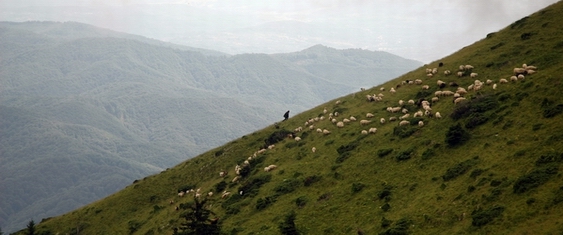
The trail proceeds to the left, on the forestry road along the Apple’s Stream. 20 minutes later, it gets to another confluence (Bulzului Stream with the Apple’s Stream), wherefrom you enter the Buila-Vânturariţa National Park (the boundary sign is the white framed red square). From the confluence point, the trail leaves the valley and goes upwards on the range between the two affluents, getting to the glades at Piciorul Mărului. The path keeps going up to the north, to the woods, wherefrom the path changes course to the east, to cross over a valley to the Bulzului glades. Leaving two sheep shelters behind, it climbs north again, through the glade. Shortly after passing another shelter on your left, there comes a crossroad marked by an arrow-pointer, where it meets trail no. 6 – the yellow dot. 100 m to the right (common track with trail no. 6), there is a range (pointer) with a white marble cross. There are the monk dwellings at Pătrunsa Hermitage in front. We leave trail 6 behind (it goes to the hermitage) and go up to the left along the range, through the glade, on the edge of the beech forest. After 10 minutes of going upwards, you’ll reach the upper part of the glade, into the beech forest and get on top of a small forested peak, and then get downwards slowly to the valley on the right, at the bottom of the cliffs. Go on by the bottom of the cliffs, pass round their right corner and up on a winding road on the western slope of the valley that comes down from Curmătura Builei. After 20 more minutes of walking up, you cross the valley and keep going up for another 10 minutes, until getting out of the forest under the impressive steep of Mount Ţucla. From hereon you will walk along to the left, among the spruce trees, near a valley, up to an arrow-pointer at the meeting with trail no. 6.
From here to Curmătura Builei (1450 m), the two trails go upwards together: ascending slowly, on the left side of the valley, then crossing it along the spring and sloping upwards for 15 minutes to the north, to the refuge at Curmătura Builei, passing near another spring. At Curmătura Builei, there is a ruined and deserted refuge and a recently rebuilt sheepfold, where there is enough room for 5-6 people, when the shephards are not dwelling there over the summer. There also is an arrow-pointer, signing the crossroad with trail no. 11, the ridge trail, represented by the red dot.


)