Hiking duration:
- on summer: 4 – 4 ½ h
- on winter: forbidden from Ştevioara Sheepfold to Ştevioara Pass
Refuges: Pahomie Hermitage, Ştevioara Sheepfold
Water sources: Pahomie Hermitage, Ştevioara Sheepfold
Description:
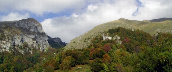
This is a difficult trail, due to the great altitude range to ascend (almost 1000 m) and by crossing some extremely exposed areas in its top part, being forbidden on winter in the alpine meadows area.
From the Pahomie Hermitage you’ll start down the forestry road to the Pătrunsa Hermitage, until getting to a spring, where there is a pointer marking the beginning of the trail.
The trail on the ridge is very rough, almost alpine. From the crossroad, it goes upwards for about 15 minutes, through the young beech forest, to the Beautiful Ridge. It then gets to a rare wood, wherefrom you have to go downwards to the right, slowly, by the bottom of the cliffs. After crossing a valley, you’ll pass through a small forested pass, and go down in a small dry valley, still very rich in vegetation, that you’ll ascent arduously for over 30 minutes, to its upper side. Cross the slope to the right on the upper side of the next valley, and after another 30 minutes, you’ll get to the edge of the forest. In the glade where there is an old sheepfold and a new one, with a small spring behind. Going left from here, after 5 more minutes of going up through the centennial beech forest, you’ll get to the alpine meadows. Up the valley to the west, keeping the spruce forest on your left and the Vânturariţa and Vioreanu Peaks on your right, after a 30-40 minutes of strenuous ascent, you’ll get to the ridge. From here, the ascent continues to the right, first on the ridge strip, then on its right, and then on the ridge again, and, after 30 minutes, you’ll get on a plateau at the bottom of Vânturariţa Peak. The trail changes track over to north-west and, after 15 more minutes, you’ll get on the ridge, in the Ştevioara Pass (1790 m), where there is another pointer that marks the crossroad with trail nr. 11, the trail of the main ridge, marked by the red dot.


)