Hiking duration:
- on summer: 7 – 8 h
- on winter: forbidden on the tract from Mount Cacova to Curm?tura Comarnice
Refuges: the Sc?ri?oara Refuge, the Sc?ri?oara sheepfold, the Cacova sheepfolds, the shelter At the Cross, the shelter Piscul cu Brazi, the Cheia Chalet
Water sources: the Sc?ri?oara Glade, the Cacova sheepfolds, At the Cross, the springs down Buila’s backside, the Comarnice glade
Description:
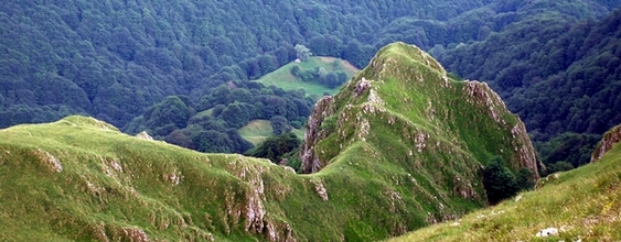
This trail crosses the north-western slopes of the Buila-Vânturari?a Massif and it connects the various paths that get to the top ridge. It is one of the most beautiful tourist trails in the area, not raising any particular difficulties in the summer time, but is not allowed during winter, because of heavy and persistent snow in the area called „the Backside of Buila”, lying beneath the north-western slopes of the ridge.
The starting point is the Pietreni village, the crossroad with the road for the B?rb?te?ti village, where there is an information board and an arrow pointer. You start to the north and, 100 m further, you get to the crossing point of several roads and trails (you’ll see a pointer). On the left side, there is the trail that goes to the Coste?ti Valley (trail no. 3). Our trail follows the forestry road on the right, on Valea Morii (also called the Dry Stream) and, 300 m further down the road, you get to a barrier that stands at the entrance in the Buila-Vânturari?a National Park, marked by an information panel. At the beginning, the trail follows the course of the valley, then it goes up the southern slope on two large curves, and then crosses over to the western slope by the upper corner of the valley and, an hour after leaving the Pietreni village, it reaches a first ridge, where you can see the sign of the boundary of the park and the one for trail no. 6 (you’ll see the pointer), marked with an yellow dot, that comes up here from the B?rb?te?ti village. From this point on, the trail shares course with trail no. 6. You will leave the forestry road, starting here, as that road makes a left, while you go over north, on the path that follows the ridge; 10 minutes later, you will get to the Sc?ri?oara Glade. You will find a refuge here, and water, an information panel and a campground with a fireplace, a table, benches and a garbage box.
From the refuge, you will cross the glade over to the east, up to its highest part, where you will get a wonderful view to the Cozia and Nar?? mountains. From the top, you will switch direction to the north, going into the woods towards the rocky area, that you cross round by a path down east. 100 m further, you reach a valley where there is a crossroad with a pointer, wherefrom trail no.6 makes a right turn, over to P?trunsa. The trail makes another turn to the left, on a small valley and then into a small glade. From here, you go up to the top over to the north-west, get into the woods for a short time, just to get back out in a larger glade, ?oprul ?olii Glade (around 1175 m), where there is a deserted sheepfold that could work as a bad weather shelter. You will then get back into a rare beech forest, cross a small pass wherefrom you can see the forestry road on your left, then go up on the trail to the north untill reaching the alpine meadows in Mount Cacova, next to the sheepfold La V?c?rie. You’ll find a water source here. From the sheepfold, you will change the direction over to the west, cross a valley down a grinding slope and go to the top on the direction of a doline near which there is the Cacova sheepfold. From this sheepfold, you will climb north up to the top, where you will fiind a pointer, marking the crossing point with the Buila-Vânturari?a ridge trail, signed by the red dot; the trail goes down to Coste?ti valley on the north-western slope of Mount Cacova. You’ve got to follow the ridge for a small track, while the two trails walk together, until you get to another arrow-pointer, and from there you get down on the north-western slope, in the forest, down to where the steep begins, where the trail keeps going north-east beneath the steepness of Mount Cacova and Piatra, mostly on a level curve. 20 minutes later, you will reach a new crossroad, marked by an arrow pointer, wherefrom the trail nr.6, signed by the yellow dot, goes down to the left, to Coste?ti Valley. Then comes a small track of sloping upwards, while the trail is also marked with an yellow dot, up to the place called At the Stone Cross, beneath Curm?tura Builei. There is a small refuge here too, a cross, a fresh water spring and an indicator, pointing out the way where trail no. 6 gets up to Curm?tura Builei.
Your trail goes on the same course over to north-east, with young mix forests on your left hand, and on the right the rocks of the Buila and ?tevioara Peaks, the steep and wild valleys that go down from the crest, forested with old centennial spruces or green with Juniper shrubs. 15 minutes later, you get into a rare forest, wherefrom you can see the sheepfold from the Backside of Buila. The path starts sloping upwards steeply, among the rocks, until the Stone Glade (approx. 1610 m), a very beautiful place, wherefrom a great view opens to the shrubby steepness. After crossing the glade and entering the spruce forest, you will go over a few valleys and, 20 minutes later, get into another glade, a smaller, more abrupt one, called The Beautiful Glade (approx. 1530 m). Once you crossed it, another 20 minutes later, through the spruce forest, there comes the third glade: Piscul cu Brazi. This is the smallest of the three important glades in the area of The Backside of Buila, but it is very beautiful. In its upper corner, there is a small refuge, set up in an old sheepfold, where you can get by going up over south. Pass the glade, you get back into the forest again, cross a large valley, where there is a spring that never goes dry, and then, 15 minutes of walking along later, you get to Curm?tura Comarnice (1525 m), in another small glade. Over here, there is a crossroad with trail nr. 17 (pointer), marked by the blue line, that comes up from the Cheia Chalet (on the same track by where our trail will go downwards), over to the main ridge of the C?p??ânii Mountains. From that glade, you go downwards to the east, on a trail among the spruces, and, 5 minutes later, you will get to the Comarnice Glade, where you can still see the ruins of an old sheepfold. There is another crossroad here, with an arrow-pointer, wherefrom the trail no. 10, marked with an yellow dot, goes up to the top, at Curm?tura Oale and then down to the Pahomie Hermitage.
From the Comarnice glade down to the Cheia Chalet there is an about 2 hours’ walk. The trail goes first over to the north, in the spruce forest, descending slowly, and then changes direction over to the east, on the southern slope of the Comarnice Valley. You’ll get in the middle of a plateau forested with spruce trees, descend to the east, passing by the left side of a glade, called „Cu Bulbuce” (approx. 1320 m), in a depressionary area and, after a short while, you reach an old tractor road. The only difficulty from hereon is the rich shrubby vegetation down the road. As you will go downwards on the winding road (there are 8 curves to the right) down to the stream and, from there, the trail follows the river, going down slowly, to the chalet.


)